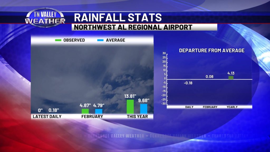
A new month means a look at that month’s climatology here in our part of the Tennessee Valley, but we also like to begin by looking back at the previous month’s rainfall stats in our area. Within our viewing area, the only NWS climate-record-keeping type reporting stations we have are located on the Alabama side of the state line… at the Northwest Alabama Regional Airport in Muscle Shoals and at Pryor Field as a proxy for Decatur. We use the stats from the Muscle Shoals location since, of the ones available to us, it is the closest to the geographical center of our viewing area counties and is best representative of at least being close to what is also observed for our southern middle Tennessee locations. With that explained after receiving a few questions on the last one or two of these, here’s what we have for the month of February…
Overall, we continued the trend of playing catchup in the rainfall department after the major drought across our area during the late summer and fall months. At the airport in Muscle Shoals, we observed 4.87 inches of rainfall for the month, only 0.08″ away (on the surplus side) of what is established as the climatological average for February at the location. This helps keep our running trend of running above average for precipitation so far for 2024, with the reporting site already seeing 13.81″ of measured precipitation (either rain, or in the case of the wintry weather in January, the melted liquid equivalent). That is 4.13″ above normal for this early in the year. After the horribly dry conditions we had just a few months ago, we will certainly take it!
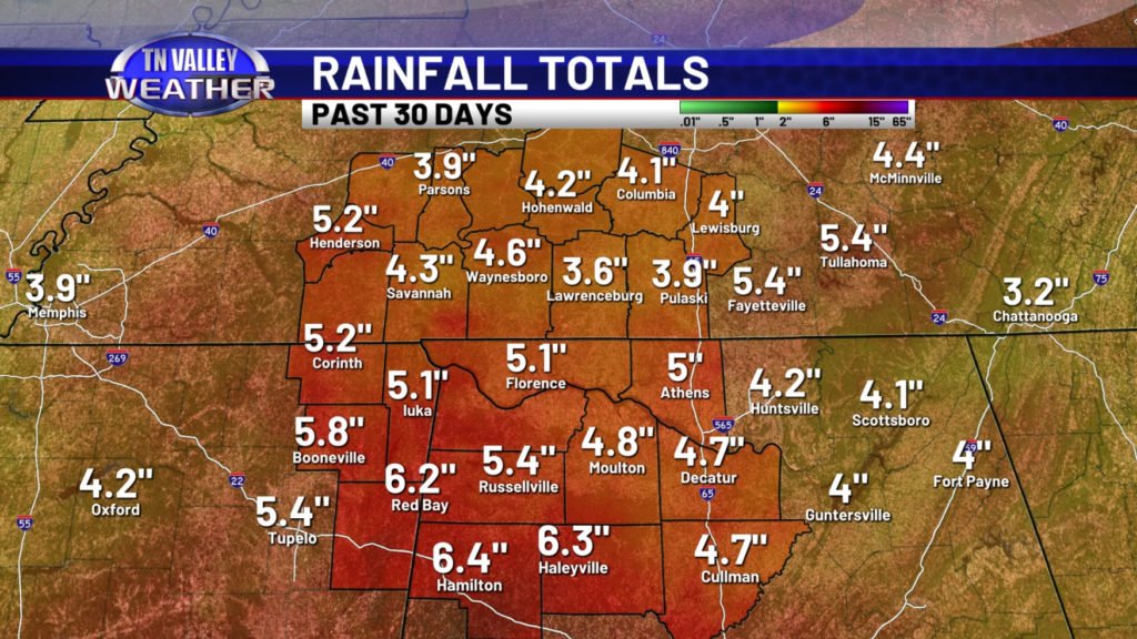
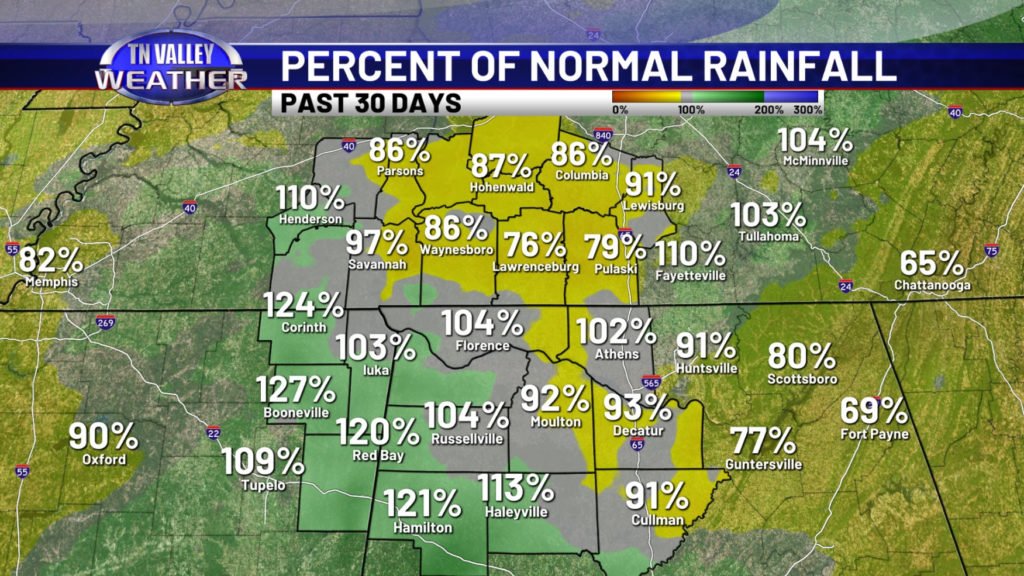
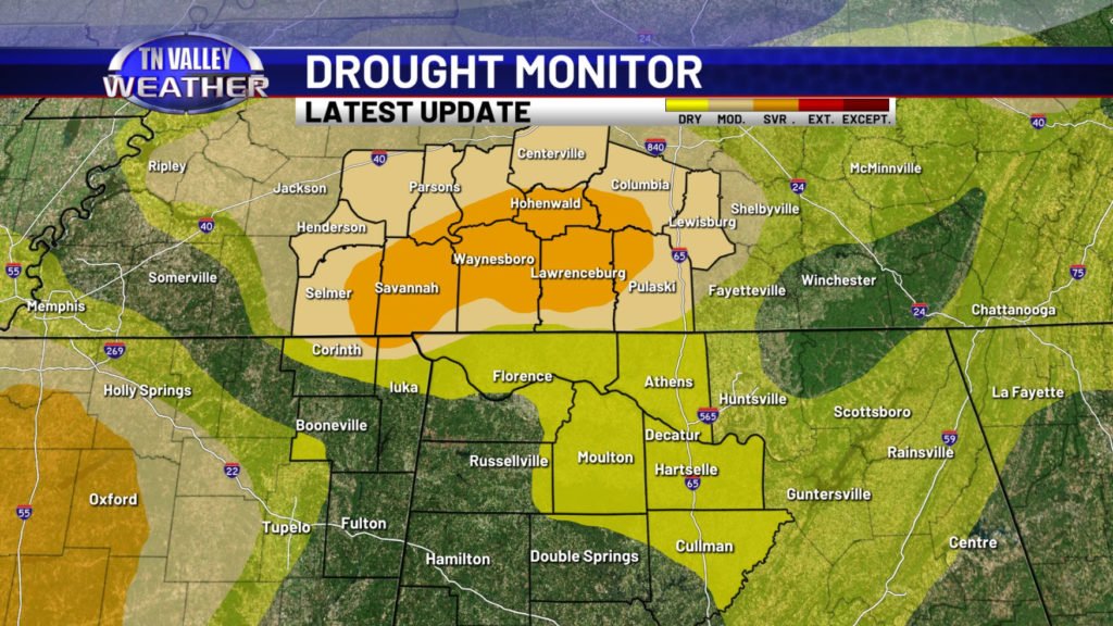
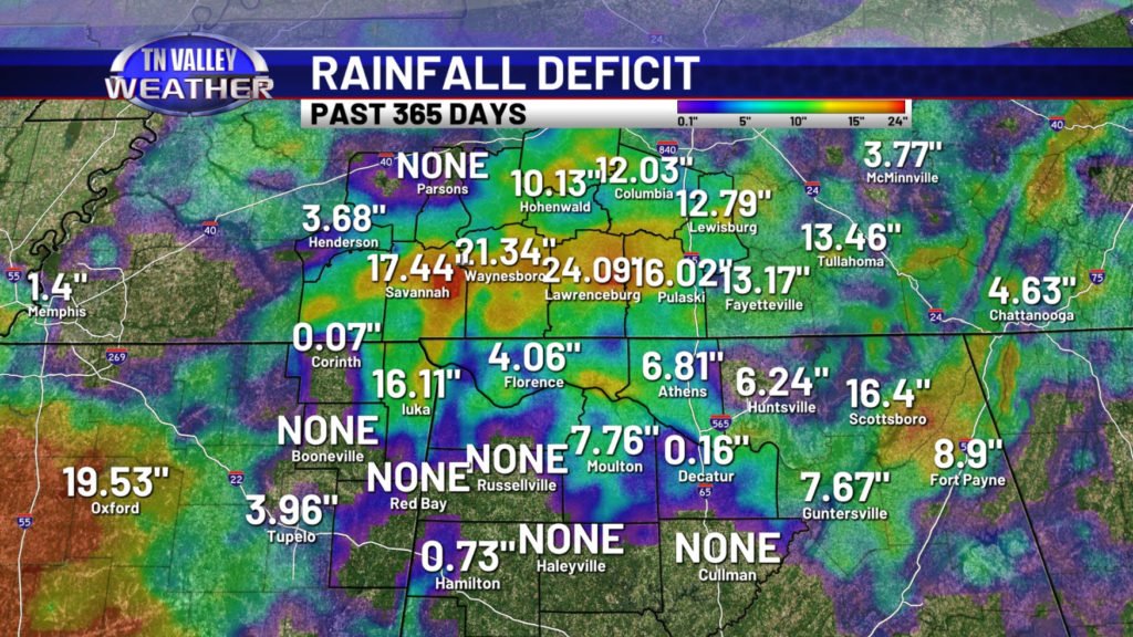
Most locations across our part of the Tennessee Valley faired decently well for rainfall this past month. Most locations came in between 3.5 and 5″, although locations south of the Tennessee River in northwest Alabama were running near 5.5 to 6.5″ of rainfall. This puts our area not too far from average, with southern middle Tennessee to the I-65 corridor of north Alabama running near to slightly below average for the month and areas south of the Tennessee River and west of I-65 across northwest Alabama into northeast Mississippi running near to a little bit above average for the month. Despite the recent catch up in rainfall that started back before Christmas, there are still officially drought conditions ongoing across our southern middle Tennessee counties. This isn’t from short-term conditions such as the near-surface soil moisture in your front yard or if the stream behind your house has gotten its water levels back up. This is because of long-term rainfall deficits across the area running as much as 1 to 2 FEET below normal across the area for the past year. It will take time to catch those up, but we have been steadily heading in the right direction, and we look to continue to do so as we head through the next few weeks and months. Spring months here coming out of a strong El Nino like we’ve had this winter are often kind of wet and active, and we’ve already been seeing this play out before our eyes. We should see even these long-term rainfall deficits significantly improve as we head through the spring.
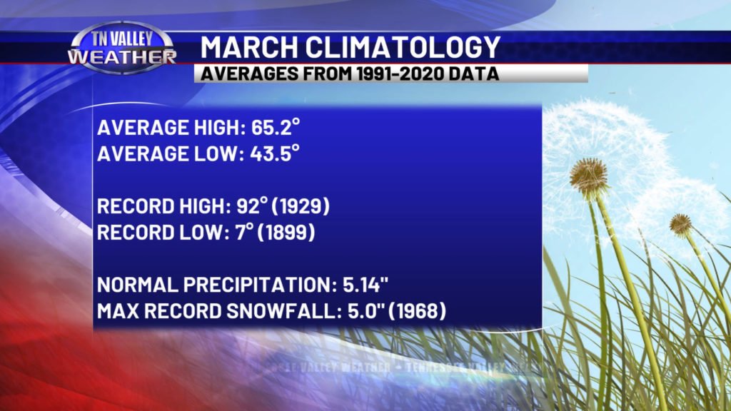
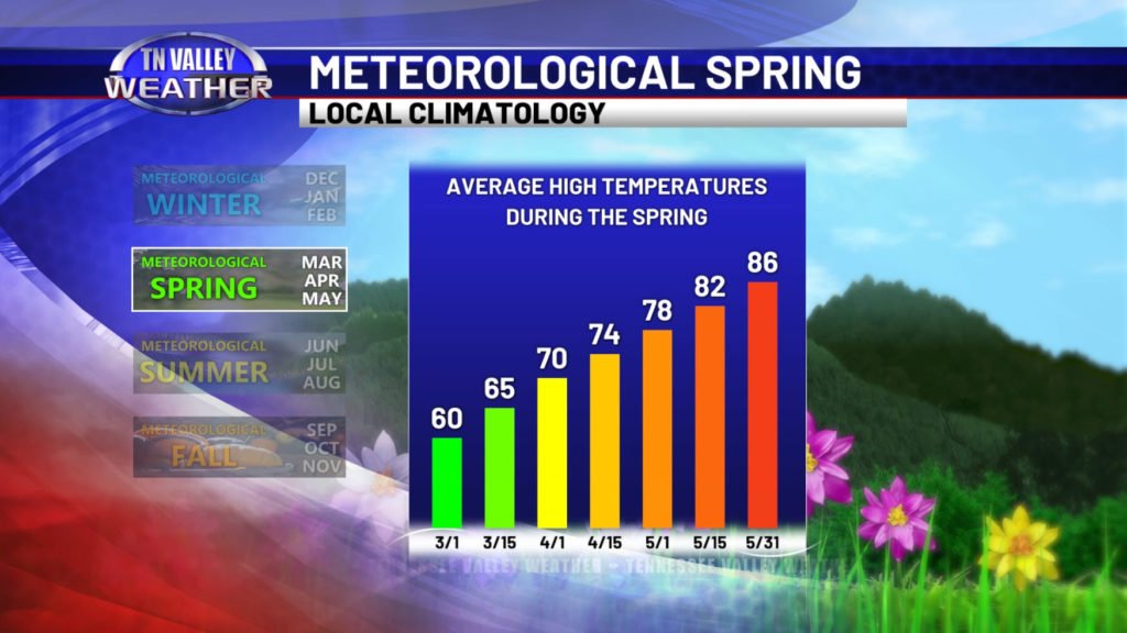
So now, we look ahead to the month of March and what local climatology shows us about how the weather can often behave here during the month. For the same reasons explained in the discussion about the rainfall stats above, we also have to use the climate data from the Muscle Shoals airport for this information as well. That means that individual record highs or record snowfall numbers may not catch an individual event that happened elsewhere in the viewing area, but it does an overall good job of showing us what is to be considered “normal” or “average” for not just northwest Alabama but our portion of southern middle Tennessee and northeast Mississippi as well. The average daytime high for March in our local area is roughly around 65 degrees, but it starts at 60 at the beginning of the month, and it has worked its way up to 70 degrees as an average high as we head out of March into April. We can certainly occasionally have much warmer weather though. The record monthly high for March at the Muscle Shoals climate recording site is 92 degrees, set in 1929! Our average low temperature is around 43-44 degrees for the month, but we can still be as low as the single digits. Muscle Shoals recorded a record low of 7 degrees in 1899, and areas as far south as Birmingham in central Alabama were into the lower single digits for overnight lows just after the blizzard that happened in March 1993!
March is often a wet and active month in the Tennessee Valley. The average monthly precipitation comes to 5.14 inches. We can occasionally get heavy rain and flooding events that can sometimes bring double that amount in a single storm system though! We can still also occasionally get wintry weather in March. Muscle Shoals recorded a monthly snow total of 5″ back in 1968, and there have occasionally been snow events in our parts of our viewing area in March that have brought double that amount!
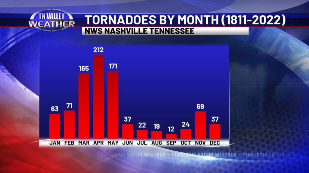
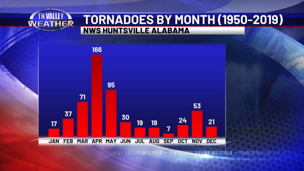
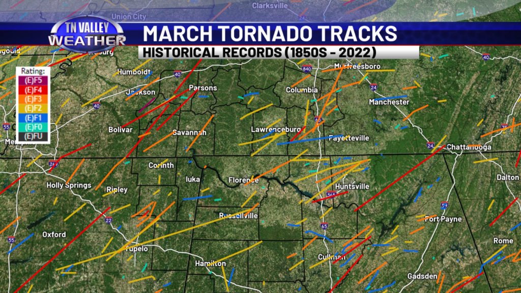

One of our primary concerns in the Tennessee Valley as we enter March is the potential for severe storms and tornadoes. We have been in our tornado season for a while, that runs from November through May, but the months of March, April, and May are historically the busiest parts of it. Tornado counts for middle Tennessee and Alabama both peak in April, but they drastically shoot up beginning in March. Over the last few years alone, we have seen multiple tornadoes in our immediate local area during the month of March, including two separate events with intense and deadly tornadoes causing fatalities in our viewing area just this past March in 2023. While long-tracked strong to violent (EF2-EF5) tornadoes can and occasionally do happen during the fall and winter months, they are statistically most likely to happen in our area during the spring months. In fact, one of north Alabama’s generational “super outbreaks” happened on March 21, 1932. That tornado outbreak produced eight separate F4 intensity tornadoes in north-central Alabama alone, and there were other intense tornadoes that day from Mississippi to Georgia and from the Tennessee Valley into the Ohio Valley. Severe storms and tornadoes are a naturally occurring part of life here in the Tennessee Valley every year. As we head into the heart of the spring stretch of our tornado season, it is vitally important that you stay prepared to react to approaching dangerous weather, have a safety plan in place ahead of time, and have multiple reliable ways of hearing warnings and watches.
