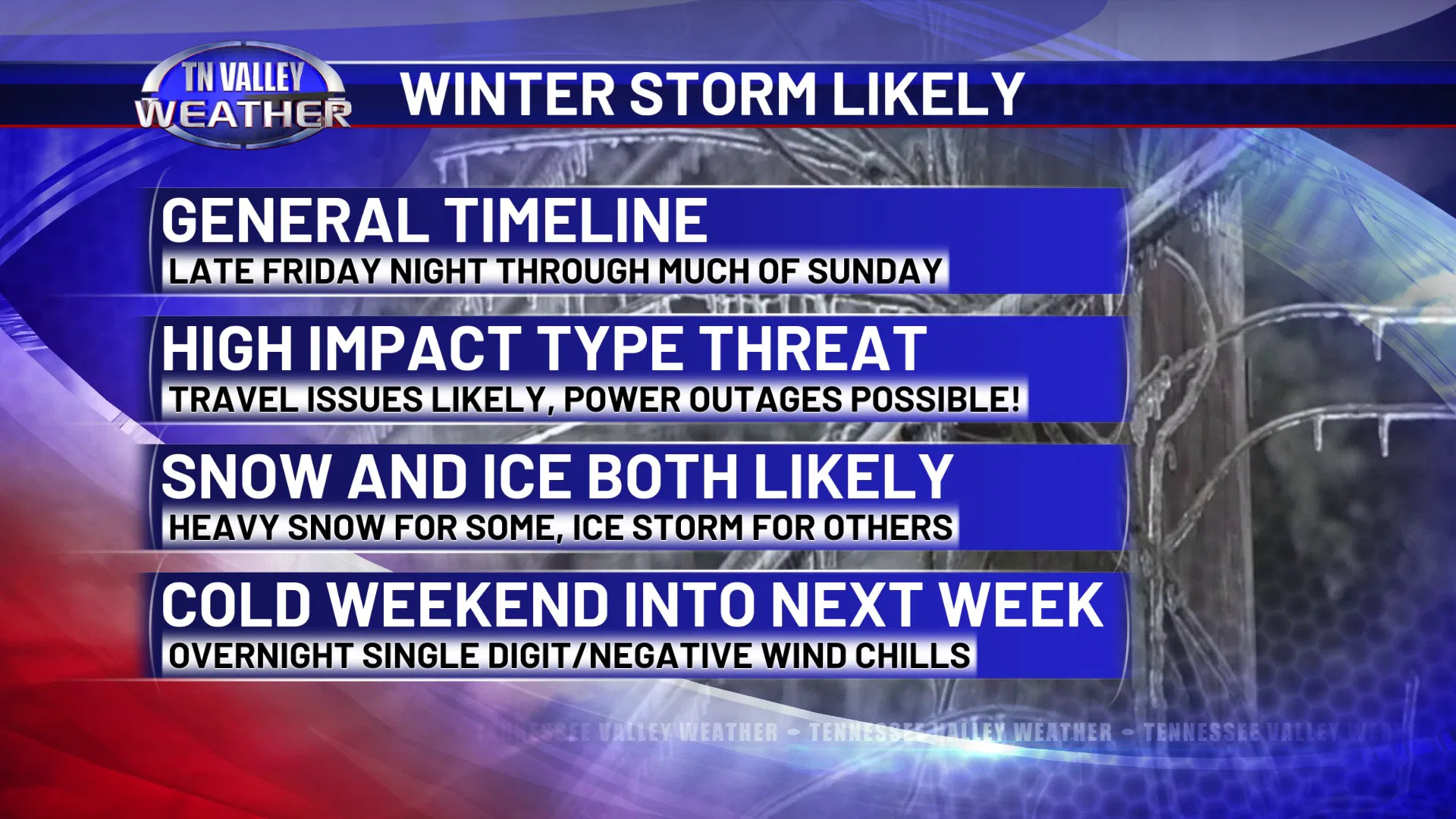

HIGH IMPACT WINTER STORM LIKELY late Friday night through much of Sunday
Confidence continues to lock in on the winter storm we have been talking about for the weekend. There is still time for small-scale, specific details to wobble around and change, but this storm has kind of driven past the off ramp exit for it to have a chance to not happen altogether.

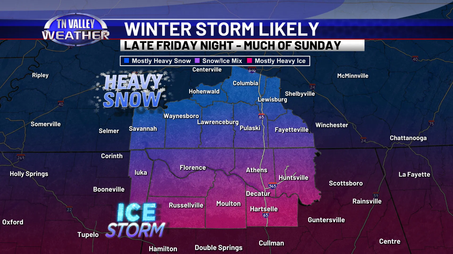
General Timeline: Starting late Friday night into early Saturday morning, then lasting all the way through a large part of Sunday based on the latest data. Precipitation may not taper off until late Sunday evening from west to east.

Heavy Snow Threat: It is still too soon to give out specific number amounts, but for the areas that stay mostly snow or all snow across our viewing area, this looks to be a heavy snow event, and total accumulations in those zones may be over 6-8″ (and that may be a low estimate). NOT EVERYONE WILL SEE SNOW THOUGH!

Ice Storm Threat: South of the zone that stays mostly snow, there will be a very real threat of a full-blown ice storm. This is because warmer air a few thousand feet above the ground will be coming up from the south while surface temperatures are in the 20s. This will cause snowflakes to melt out of the clouds as they fall and then either refreeze on the way down as sleet, or fall as liquid rain and then freeze on contact and glaze everything over. Sleet would be major road issues, but wouldn’t cause much power disruption. If it’s a glaze of ice, that is what weighs heavily on tree limbs, power lines and power poles, and causes widespread and longer-duration power outages. We are still trying to get a sense of the “flavor” of the ice storm in those areas, but we get the idea that it may be freezing rain instead of sleet for many folks in north Alabama, especially south of the Tennessee River.

Transition zone: There will be a zone roughly between US Highway 64 in Tennessee and either US Highway 72 or the Tennessee River in north Alabama where the precipitation may be a mix of sleet, freezing rain, and snow. This would STILL lead to widespread travel issues and power outage potential. This zone may also waffle north or south a few miles over the next few days as we get closer. This waffling around of the transition zone is why we CAN’T give specific snow totals or specific ice totals this far in advance. We will begin to have enough confidence in smaller-scale details to publicly talk about those number ranges once we get to about Thursday afternoon/evening.

Travel Problems: Regardless of whether your location is snow, sleet, freezing rain, or a combination of those, widespread travel issues will be likely. With how much wintry precipitation that is expected to accumulate and the fact that cold air will continue into at least early next week, there may be road problems… especially on secondary and back roads… into at least the first couple of days of next week, if not beyond. Once you get where you’re going to be Friday night, plan on being there for a few days.

Power Outages: The higher concern for power outages, especially those that are more widespread and/or longer in duration, will be in the areas that stay mostly freezing rain. That’s because that causes a glaze of ice that weighs down trees and tree limbs, power lines, power poles. That makes it easier for them to snap and cause problems. If ice accumulations in those areas end up exceeding half an inch, there could be power outage problems that last for several days or longer.

In addition to the wintry precipitation, cold temperatures and dangerous wind chills will be a big problem, and this continues into next week. We will be below freezing non-stop from Friday night into at least Monday or Tuesday afternoons, with overnight lows in the single digits to lower teens likely once the storm itself ends. During the overnight periods, wind chill values as low as the single digits and below zero values are possible (if not likely) from the weekend into at least early next week.

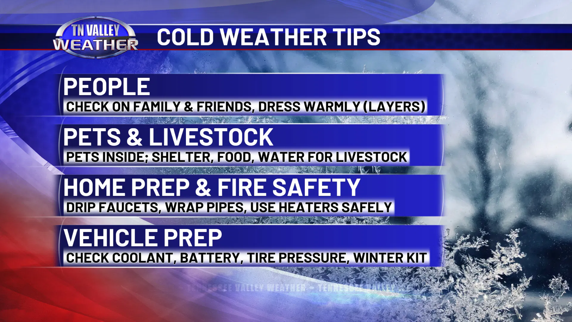
Now is the time to make your preparations. DON’T WAIT until we can give out specific snow totals or specific ice totals. That doesn’t matter! What matters is you knowing ahead of time that the storm is coming, that travel and power disruptions are possible, that seriously cold temperatures and wind chill values will be present too, and that you need to prepare for those things.