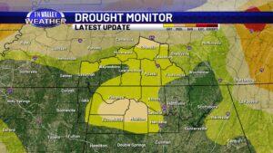
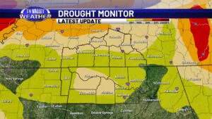
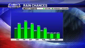
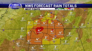
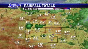
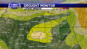
skip to content

Author name: Fred Gossage

Chief Meteorologist of the Tennessee Valley Weather Team

Two periods of active weather in the Tennessee Valley: Strong storms possible Friday PM, then wintry like cold and flurries possible to start next week!

Friday, especially in the afternoon and evening, will feature the potential for a few strong to severe storms across the Tennessee Valley. There is currently a low-end Level 2 of 5 risk outlined across all of southern middle Tennessee, down into parts of north Alabama, and into far northeast Mississippi. Outside of that, there is […]

Two periods of active weather in the Tennessee Valley: Strong storms possible Friday PM, then wintry like cold and flurries possible to start next week! Read More »

November is right around the corner. Here’s a look at climatology stats for our part of the Tennessee Valley.

November arrives on Saturday. It’s hard to believe we’re flying this quickly toward the end of the year, but here we are! As we head into November, we are heading into home stretch for meteorological fall here in the Tennessee Valley. Typically, the main storm track comes southward and gets more active. We shift out

November is right around the corner. Here’s a look at climatology stats for our part of the Tennessee Valley. Read More »

An update on drought conditions in our part of the Tennessee Valley

The latest Drought Monitor update issued this morning by the NWS Climate Prediction Center shows that some portions of our area still remain in “Abnormally Dry” or in drought classifications, but that there have been no major changes. In fact, if anything, areas of western Colbert and Franklin Counties in Alabama back into southern Tishomingo

An update on drought conditions in our part of the Tennessee Valley Read More »

The fall portion of the Tennessee Valley’s severe weather season is right around the corner. Here’s some important preparedness information!

As we head into the cooler months of the year, the jet stream becomes more active as it comes back southward toward our area… bringing with it more frequent weather systems and a return to severe weather “season” in the Tennessee Valley. Severe storms and even tornadoes can happen at any time of the year,

The fall portion of the Tennessee Valley’s severe weather season is right around the corner. Here’s some important preparedness information! Read More »

A quick update on rainfall stats and drought conditions across the Tennessee Valley

As of the latest drought monitor that was issued this past Thursday, we’ve been able to hold off major drought conditions across our part of the Tennessee Valley. As a matter of fact, there has actually been significant short-term improvement across the Highway 412 corridor of southern Tennessee in what was red on this map

A quick update on rainfall stats and drought conditions across the Tennessee Valley Read More »

Dry weather ahead. So are seasonable temps for a few days before trending warmer next week.

Skies will continue to gradually but steadily clear as we head into the overnight. Breezy north to northeast winds will continue as well, sustained around 10 mph and gusting as high as 15 to 20 mph at times. That will bring in cooler and drier air, with overnight lows down into the low to mid

Dry weather ahead. So are seasonable temps for a few days before trending warmer next week. Read More »

The Enderlin, ND tornado from June 20, 2025 upgraded to EF5. Why that is a “big deal” in the weather community and a look at some stats and misconceptions about EF5 tornadoes and the Enhanced Fujita Scale

If you’re any kind of weather enthusiast at all, you’ve likely heard that the Enderlin, North Dakota from the late evening of June 20, 2025 was officially upgraded to an EF5 rating as of this Monday morning. That information was released from the Grand Forks, ND local office of the National Weather Service and was

The Enderlin, ND tornado from June 20, 2025 upgraded to EF5. Why that is a “big deal” in the weather community and a look at some stats and misconceptions about EF5 tornadoes and the Enhanced Fujita Scale Read More »

Warm and mainly dry through the week. Rain chances begin to return early next week?

If you enjoyed the weather on Monday, we expect more of the same for today. Mostly sunny skies, warm temperatures, and a light north to northeasterly wind. Daytime highs this afternoon will be in the mid to upper 80s. There’s a 10% or lower chance of a spotty stray sprinkle or shower today over north

Warm and mainly dry through the week. Rain chances begin to return early next week? Read More »

Heavy rain and flooding last night into today. Showers and storms still around but becoming more scattered with time.

It’s been an active past few days across the Tennessee Valley with multiple rounds of heavy rain and thunderstorms, leading to flash flooding in some areas. Just since early last evening, a large part of southern middle Tennessee has seen near or over 2 inches of rain, with a large swath of 4 to 6

Heavy rain and flooding last night into today. Showers and storms still around but becoming more scattered with time. Read More »