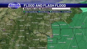
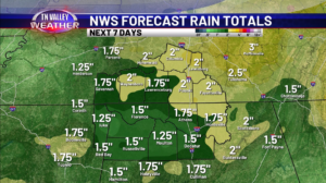
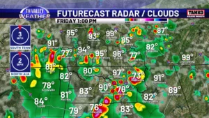
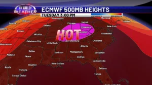
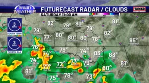
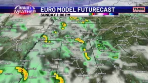
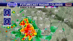
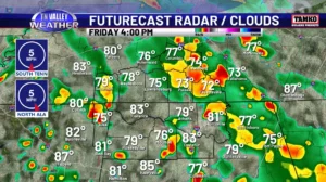
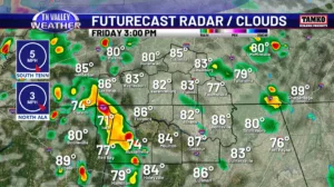
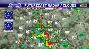
skip to content

Author name: Taylor Plott

Spring Like Weather Makes an Appearance Next Week…Rain Chances Increase Tuesday…

Happy Friday! Another dry day is in store for us today and even a bit warmer. Highs will be in the upper 50s and lower 60s across the area with a mix of sun and clouds during the afternoon hours. This evening, clouds will continue to build in but we will remain dry. Lows will […]

Spring Like Weather Makes an Appearance Next Week…Rain Chances Increase Tuesday… Read More »

Flurries and Snow Showers Friday and Saturday…Very Cold Temps Coming In!

Good Thursday morning! We continue our dry stretch of weather today before some snowflakes occur tomorrow and Saturday. For today, expect partly cloudy skies with highs in the lower 40s. This evening, we will drop down into the low to mid 20s overnight, so not as chilly but still below freezing. During the day on

Flurries and Snow Showers Friday and Saturday…Very Cold Temps Coming In! Read More »

Winter Storm Moves in Overnight Tonight…High Impacts Likely For Parts of the Tennessee Valley…

Good Friday morning! While the entirety of the day today will be dry, our winter storm will be moving in overnight tonight. Please finish up any preparations you need while you can today! During the overnight hours, some snow, sleet, and freezing rain will begin to move in from the west. Most of this will

Winter Storm Moves in Overnight Tonight…High Impacts Likely For Parts of the Tennessee Valley… Read More »

Winter Storm Moves In Late Friday Through Sunday…Some Will See Ice While Others Mainly Rain…

Good Thursday morning! We will see dry weather today before our winter storm sets in late tomorrow. For today, expect partly cloudy skies with highs in the upper 40s and lower 50s. Winds will be out of the south and southeast around 5-10mph. Our main focus forecast wise is our winter storm moving in late

Winter Storm Moves In Late Friday Through Sunday…Some Will See Ice While Others Mainly Rain… Read More »

Flash Flooding Possible Today and Tonight…Strong Storm or Two Still Possible…Much Cooler Next Week!

Good Friday morning! We continue to monitor our rain and storms this morning with the threat for some flash flooding. A strong storm or two will still be possible this afternoon and into the overnight hours, but that risk is very low. Most if not all the severe threat today will be off to our

Flash Flooding Possible Today and Tonight…Strong Storm or Two Still Possible…Much Cooler Next Week! Read More »

Strong to Severe Storms Possible Tomorrow…Much Cooler Weather Sunday and Into Next Week

Good Thursday! We are looking at warm and dry weather for today but that will change once we get into late tonight and tomorrow. Expect highs today to be in the lower 70s for most places with a breezy wind at times. During the late evening and early overnight hours, we will be tracking a

Strong to Severe Storms Possible Tomorrow…Much Cooler Weather Sunday and Into Next Week Read More »

Slightly Cooler Temperatures This Weekend…Much Warmer Christmas Eve and Day…

Happy Friday! After a rainy and stormy day yesterday, we are looking at a great day weather wise today with abundant sunshine and highs in the mid 40s. Winds will be a bit breezy at times out of the north with gusts around 15-25mph. This evening, with the clear skies continuing, our temperatures will drop

Slightly Cooler Temperatures This Weekend…Much Warmer Christmas Eve and Day… Read More »

Storms Track Through Later Today…Very Mild Weather for Christmas Week…

Happy Thursday! Periods of rain will continue through the rest of the day today with highs in the upper 50s and lower 60s. Later this afternoon and evening, storms will start to track in from the west with the approaching cold front. While some of these storms could be strong at times, the overall severe

Storms Track Through Later Today…Very Mild Weather for Christmas Week… Read More »