Fantastic Weather Continues Today and Tomorrow…Rain Chances Return Starting Sunday…
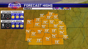
Happy Friday! Another great day weather wise is expected with a lot of sunshine and highs in the mid 70s. Some passing clouds can be anticipated as well but we are rain free today. This evening, we will see our temperatures cool off into the 50s overnight, with perhaps some upper 40s in the typical […]
Fantastic Weather Continues Today and Tomorrow…Rain Chances Return Starting Sunday… Read More »