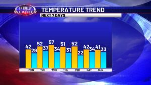
skip to content

Author name: Kelli Rosson

Early week t’storm chance. Relatively quiet mid-week with warm temps.

We’ve already had thunderstorms wake some of us up this morning, especially if you are west of Highway 43. Storms have not been severe but they have been dumping heavy rainfall and producing frequent lightning. Thunderstorms will continue west of Highway 43 until mid to late morning, but the rain chance doesn’t end there. Pop-up […]

Early week t’storm chance. Relatively quiet mid-week with warm temps. Read More »

Hot start to the week. Rain and storm chances increase Wednesday.

We have a hot few days ahead of us across the Tennessee Valley. A Heat Advisory is in effect for both this afternoon/evening as well as tomorrow (Tuesday). Heat index values (feels-like temps) may reach up to 108° during peak daytime heating hours. Remember your heat precautions, stay hydrated, and take breaks indoors. Expect a

Hot start to the week. Rain and storm chances increase Wednesday. Read More »

Cooler start to the week with daily rain and storm chances. Warmer by the weekend.

This first Monday of August is off to a gloomy and cool start. Clouds stick around for much of today for the majority of the viewing area. Highs this afternoon will only reach the upper 70s for some, mainly around and east of I-65, while folks out west may see more sunshine and highs in

Cooler start to the week with daily rain and storm chances. Warmer by the weekend. Read More »

Intense heat to start the week. Thunderstorm chances and a weekend cool-down.

If you thought last week was hot, this week’s heat will be even more intense. This morning is off to a partly cloudy start across the Tennessee Valley. A few thunderstorms will pop up by the afternoon, but they will be spotty in nature with some folks staying dry. Highs this afternoon will be in

Intense heat to start the week. Thunderstorm chances and a weekend cool-down. Read More »